El Niño is underway in the tropical Pacific and is expected to strengthen through the 2026–27 summer. For Australia, that does not guarantee severe emergencies, but it does raise the likelihood that existing dry conditions, fire weather, heat stress and water pressure will persist or worsen in some regions.
Main Finding
The main planning message is straightforward. El Niño is now part of the seasonal risk picture, and it is acting on top of conditions that were already dry in parts of southern and eastern Australia before the event was formally declared.
That matters because emergency risk is not driven by El Niño alone. The impact depends on rainfall, temperature, wind, fuel condition, soil moisture, water storages, local exposure, community vulnerability and the capacity of emergency services to respond.
At this assessment date, the clearest national concern is drought and water stress, followed by bushfire and grassfire risk, heat-related health demand, and smoke impacts in fire-affected regions. Dust storms, severe storms, flash flooding, tropical systems, frost and reduced alpine snow also remain relevant. Some of these hazards may increase together rather than one at a time.
What Is Happening in the Pacific?
El Niño is a climate pattern that begins in the tropical Pacific Ocean and can influence weather across Australia. In broad terms, it usually shifts rainfall and temperature patterns in ways that increase the chance of a drier and hotter season in many parts of the country, especially in the south and east.
At the June 2026 assessment point, Australian and international climate monitoring indicated that tropical Pacific sea temperatures had passed El Niño thresholds and atmospheric conditions were reinforcing the ocean warming. The Bureau’s public monitoring and forecast material indicated that the event was underway and expected to strengthen.
NOAA’s June 2026 ENSO diagnostic discussion also indicated high confidence that El Niño would continue through the 2026–27 summer. As always, the exact timing, strength and Australian impacts should be checked against the latest official updates before publication or operational planning.
The important distinction for emergency planning is this: El Niño is a climate driver, not a disaster by itself. A stronger El Niño can increase the odds of unfavourable patterns, but local rainfall and fire outcomes still depend on the weather that actually occurs.
For practitioners, this means the Pacific signal should be treated as an early warning input, not a forecast of a specific event. It supports preparation for dry fuels, warm days, water stress and seasonal volatility, while still allowing for short periods of rainfall, storms or relief.
Conditions Already Affecting Australia
Some of the risk described in this assessment existed before El Niño was formally declared. That is important because the event may extend or worsen existing pressures rather than create them from scratch.
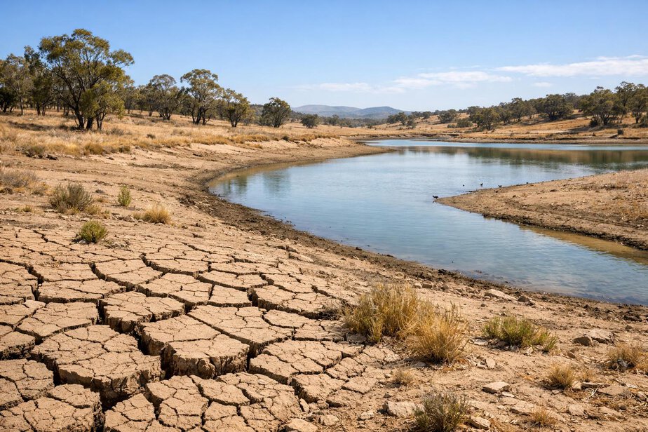
Before mid-June 2026, serious or severe 24-month rainfall deficiencies were already present in parts of South Australia, Victoria, southern New South Wales, Tasmania and south-west Western Australia. In practical terms, that means some landscapes, farms, town water systems and ecosystems had already been living with reduced rainfall for an extended period.
Murray–Darling Basin water storage was approximately 46% full on 3 June 2026, which is not the only measure of water stress but is a useful indicator of reduced buffering capacity if dry conditions continue. In dry years, low inflows can quickly limit options for agriculture, town supply, environmental watering and firefighting support.
AFAC identified above-normal winter fire potential in drought-affected areas of central and northern New South Wales, and increased winter fire potential in parts of northern Western Australia. Emergency authorities were also closely monitoring dry areas of south-eastern Australia.
The Bureau’s July-to-September outlook showed increased odds of below-average rainfall in several southern and eastern areas, with some southern areas also showing an increased chance of unusually low rainfall. Most of Australia south of the tropics also had an increased likelihood of above-average daytime temperatures during the same period.
How the Planning Percentages Were Calculated
The planning percentages in this assessment are operational estimates designed to help emergency services compare hazards and allocate attention. They are not official probabilities that a disaster will occur.
The calculation used is:
Planning score = 50% forecast signal + 30% current conditions + 20% historical El Niño relationship
In this framework:
- F means the official forecast signal
- C means current drought, water, soil, fuel or ocean conditions
- H means the historical relationship between the hazard and El Niño
The weighting gives most importance to the forecast signal, but still recognises that current conditions and history matter. This is useful because a weak forecast signal can still produce serious impacts if fuels are dry and exposure is high, while a strong El Niño signal may have smaller effects where local conditions are wet or response capacity is strong.
The planning percentages also allow for uncertainty. Rainfall, wind, ignition, fuel condition, local geography, community vulnerability and emergency response capacity all shape the actual outcome. That is why the planning range should be read as a preparedness guide, not a prediction.
National Emergency Risk Table
| Hazard | Forecast signal score | Current conditions score | Historical relationship score | Operational planning range | Overall concern level | Main areas potentially affected |
|---|---|---|---|---|---|---|
| Drought and water shortage | 70 | 80 | 85 | 65–85% | Very high concern | South Australia, Victoria, southern New South Wales, Tasmania, south-west Western Australia, inland agricultural districts |
| Bushfire and grassfire escalation | 70 | 75 | 75 | 60–80% | High concern | Central and northern New South Wales, parts of northern Western Australia, inland and southern fire-prone districts |
| Heatwave and health-service surge | 70 | 65 | 60 | 55–75% | High concern | Most of Australia south of the tropics, urban heat islands, rural towns, aged-care and health facilities |
| Smoke and poor air quality | 65 | 60 | 65 | 50–70% | High in fire-affected regions | Downwind population centres, regional towns, transport corridors, vulnerable indoor environments |
| Dust storms and visibility disruption | 65 | 50 | 55 | 45–65% | Moderate, but locally high | Dry inland districts, exposed transport routes, agricultural regions, regional airports |
| Severe storms and flash flooding | 45 | 60 | 50 | 40–60% | Moderate and still significant | Eastern and northern Australia, local catchments, urban drainage systems, tropical and subtropical regions |
The table is a planning aid only. It should be read alongside local intelligence, incident trends, fuel management information, health-system capacity, water supply status and community vulnerability.
Drought and Water Shortage Risk
Drought and water stress are the clearest national El Niño-related concerns in this assessment. The historical link is strong, although not absolute. Nine of eastern Australia’s ten driest winter–spring periods occurred during El Niño years. In the Murray–Darling Basin, winter–spring rainfall during El Niño events has historically averaged 28% below the long-term average.
Those figures do not mean every El Niño becomes a drought. They do mean the odds of prolonged water stress rise when the land is already dry and rainfall prospects are poor.
The practical consequences can be broad:
- Farms and livestock: less pasture growth, higher feed costs, stock water pressure and reduced carrying capacity
- Rural drinking water supplies: tanks, bores and small systems may need more frequent monitoring and augmentation
- Town water planning: councils may need to review demand assumptions, drought restrictions and backup sources
- Environmental water: stressed wetlands and river systems may face harder trade-offs
- Industrial supply: some sites may need contingency planning if inflows remain weak
- Firefighting water access: dam levels, carting requirements and refilling logistics can become more difficult
- Catchment inflows: low rainfall can reduce runoff even when brief showers occur
Dry conditions also affect recovery. If soils remain dry, later rain may first refill deficits rather than restore streamflow. That means some communities can see rainfall without seeing meaningful relief in storage or groundwater.
It is still important to avoid overstatement. Widespread drought does not occur during every El Niño event. Some regions receive useful rainfall, and some dry areas improve because of local storms or a change in circulation. The risk is elevated, not predetermined.
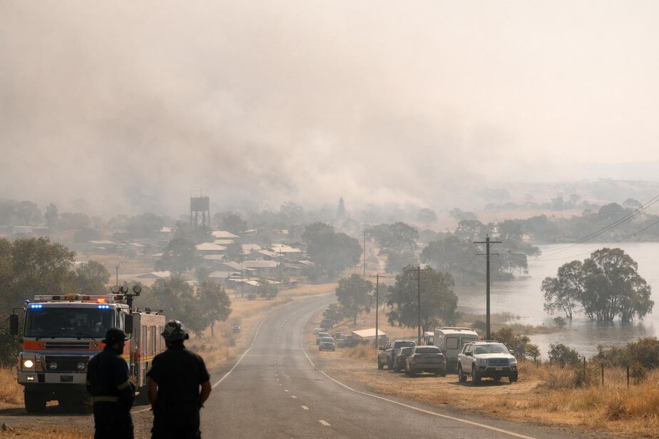
Bushfire and Grassfire Risk
El Niño commonly increases bushfire and grassfire risk by reducing rainfall, increasing daytime temperatures, drying vegetation and lowering soil and fuel moisture. That is especially important where there is already curing grass, dry forest litter or a build-up of fine fuels.
A possible positive Indian Ocean Dipole could strengthen drying across southern and eastern Australia, but the development and strength of the Indian Ocean Dipole remained uncertain at the assessment date. It should therefore be treated as a conditional modifier, not a settled part of the forecast.
AIHW data indicate that average bushfire-related injury hospitalisation rates were approximately 1.6 times as high in El Niño years as in La Niña years. The reported rates were 0.44 hospitalisations per 100,000 people in El Niño years and 0.27 per 100,000 people in La Niña years. That does not prove causation for any single season, but it does support the need for stronger readiness when dry and hot patterns begin to align.
The likely progression is uneven through the season.
Winter 2026
Winter concern is greatest in central and northern New South Wales and parts of northern Western Australia, where AFAC had already identified above-normal fire potential. Dry grass and early curing can create fast-moving grassfire conditions even when the broader fire season is still developing.
Spring 2026
If rainfall remains low, concern may spread across New South Wales, Victoria, Tasmania, South Australia and parts of Western Australia. This is the period when drying fuels, warm days and windy fronts can combine to create more active fire weather.
Summer 2026–27
By summer, accumulated drying may leave some landscapes primed for more severe fire-weather periods, especially if heat persists and fuel moisture remains low. That does not mean a Black Summer-scale season is forecast. It does mean agencies should plan for potentially difficult operational windows, including rapid grassfire spread and dangerous fire behaviour on select days.
For responders, the priority is to distinguish between broad seasonal risk and local ignition risk. Not every district will be equally exposed. Roadsides, grazing country, unmanaged grass and edge communities can become critical ignition or exposure zones even when the broader state picture is mixed.
Heatwave and Health-Service Risk
Extreme heat is one of Australia’s major direct weather-related health threats. It can affect people quickly, overwhelm services and compound other hazards such as power failures, smoke and fire response.
AIHW information for 2012 to 2022 shows that heat accounted for approximately 78% of recorded extreme-weather injury hospitalisations. Approximately 7,104 heat-related hospitalisations were recorded, and nearly one-third of extreme-weather injury hospitalisations involved people aged 65 or older.
These figures support a simple planning conclusion. Even where a heat event does not become headline news, it can still create a substantial burden on hospitals, paramedics, general practice, aged-care services and community support networks.
At the assessment date, long-range temperature forecasts did not yet provide precise summer conditions. That means the summer planning range carries more uncertainty than some other hazards. Still, most of Australia south of the tropics had an increased likelihood of above-average daytime temperatures for July to September, and dry soils can make later heat more intense.
Emergency planning should consider:
- heat illness and dehydration
- ambulance demand
- hospital and health-service pressure
- welfare checks for isolated people
- aged-care facilities and supported accommodation
- outdoor workers, including agriculture and construction
- firefighter heat stress and rehabilitation needs
- electricity and cooling failures
- medication storage and refrigeration issues
- fatigue-related vehicle and machinery incidents
Heat can also increase the risks around other events. Fire crews working in hot conditions fatigue faster. Older people may struggle to keep cool during smoke events. People in temporary accommodation may have limited access to air conditioning. These are practical, not theoretical, concerns.
Smoke and Air-Quality Risk
Smoke and poor air quality are driven mainly by fire activity, which is why this score is lower than the direct bushfire score. Not every fire produces widespread smoke exposure, and not every smoke event is prolonged. Even so, smoke can travel hundreds or thousands of kilometres and affect people far from the fire ground.
Smoke planning should cover a wider population than the immediate incident area. The main consequences include asthma and respiratory distress, reduced visibility, road and aviation disruption, hospital and pharmacy demand, outdoor-event disruption, school and workplace disruption, and added risk for aged-care residents and people without effective air conditioning or air filtration.
Smoke is also a communication challenge. People may not see fire nearby but can still be exposed to harmful air. Councils, health services and emergency agencies should have simple public messages ready on when to stay indoors, how to reduce indoor smoke infiltration and when to seek medical care.
For transport and aviation operators, smoke can create abrupt visibility and air-quality problems without much warning. That makes it useful to link smoke planning with fire monitoring, not just with direct incident response.
Dust-Storm Risk
Dust storms are a realistic side effect of dry landscapes, sparse vegetation and strong frontal winds. They are not always a large national hazard, but they can become locally severe and create sudden disruption.
At a practical level, dust can reduce road visibility, affect freight movement, disturb airports, worsen respiratory symptoms and complicate incident response in rural districts. In some cases, dust can also signal that the landscape has become highly erodible and that water and ground cover stress is very advanced.
The risk is highest where dry soils, overgrazed paddocks, bare ground and windy weather overlap. That means inland agricultural areas, transport corridors through exposed country and some post-fire landscapes should all keep dust in their seasonal planning.
It is important not to treat dust as a separate problem detached from drought and fire. Often it is a visible marker of the same underlying dryness that also raises fire and water risks.
Severe Storm and Flash-Flood Risk
El Niño does not remove storm or flood risk. It can change where and how that risk appears. Some regions may still experience damaging thunderstorms, intense rainfall, flash flooding or localised wind damage even while the broader season is drier than average.
In this assessment, severe storms and flash flooding carry a moderate but still significant risk. The reason is simple: emergency damage often comes from short, intense bursts of rain rather than seasonal totals. Dry catchments can still flash quickly if a strong storm sits over the same area, and urban drainage systems can be overwhelmed by intense rainfall even after a dry period.
Tropical cyclones and tropical lows remain relevant, especially in northern Australia, although their track, intensity and rainfall impacts are highly variable. Some El Niño years suppress tropical cyclone activity in parts of Australia, but this does not eliminate the hazard. Coastal and inland communities should still maintain seasonal cyclone and flood readiness where relevant.
The public should not assume that a dry season means no flood risk. Nor should planners assume a single wet event will end seasonal water stress. Dryness and flash flooding can occur in the same year, sometimes in the same district.
Other Important El Niño Effects
Several additional effects deserve attention even though they are not always the main public focus.
Frost and Agricultural Damage
Clearer skies, lower humidity and cool nights can increase frost risk in some inland and agricultural districts. Frost can damage crops, slow pasture recovery and affect horticultural production, especially when plants are already under moisture stress.
Reduced Alpine Snow and Rescue Variability
Reduced snow cover is a common concern in warmer and drier periods. Less snow can affect seasonal tourism, alpine water storage, ecosystem behaviour and the timing of rescue operations. It can also change access conditions, making some rescues easier and others harder depending on terrain and weather.
Community Stress and Recovery
Dry, hot seasons often create cumulative pressure rather than one dramatic incident. Water restrictions, livestock feed costs, repeated fire warnings, smoke, poor sleep and financial strain can all wear down community resilience. That matters for recovery, not just response.
Priority Actions for Emergency Services
Emergency services and local government should treat this as a season for layered preparation, not single-hazard planning.
- review drought, fire and heat triggers together rather than separately
- identify communities with existing water stress and limited recovery capacity
- check tanker, relay and refilling arrangements for bushfire response
- test smoke, heat and air-quality public messaging before it is needed
- prepare welfare checks for isolated, older and medically vulnerable people
- ensure hospitals, aged-care providers and local councils have heat escalation plans
- coordinate with water utilities on storage, restrictions and contingency sources
- brief rural fire, land management and road authorities on likely dry-land ignition corridors
- map where dust may disrupt transport, aviation or incident access
- maintain flood and storm response readiness even during a dry winter
For trained and authorised responders, the key is cross-agency integration. Fire, health, water, welfare, transport and local government systems should not wait for separate incidents to emerge before sharing situational awareness.
Practical Preparation for the Public
Households and small businesses can reduce risk with practical steps.
- store enough drinking water for short disruptions
- check tank levels, pumps and bore reliability if you rely on off-grid supply
- clear gutters, remove dry debris and maintain defensible space where appropriate
- service cooling systems before peak heat
- prepare a plan for smoke days, including indoor filtration if available
- keep medicines and refrigerated items safe during power failures
- know local emergency warnings and evacuation routes
- follow road and aviation advice during dust, smoke or flood events
- look after neighbours who may struggle in heat, smoke or water restrictions
People in rural areas should also plan for long travel distances to services, reduced water access and possible interruptions to freight and supply chains. A dry season can affect more than farms and firegrounds.
Important Uncertainties
The main uncertainty is not whether El Niño is present. It is how strongly it will interact with Australian weather systems over the coming months.
Several things could change the practical outcome:
- rainfall from individual cold fronts, troughs or thunderstorms
- the eventual strength and timing of the Indian Ocean Dipole
- the persistence of dry soils and vegetation curing
- local fuel reduction, land use and previous fire history
- community preparedness and response capacity
- the timing of hot, windy days during the fire season
- the location of any tropical lows, cut-off lows or severe storm outbreaks
Because of these variables, the planning ranges should be used as guidance for readiness rather than as a forecast of outcomes. A season that begins quietly can still deteriorate if rain fails to arrive and heat builds later.
It is also worth noting that the strength of El Niño does not automatically determine the severity of its effects in Australia. A strong event can produce limited local impact in some regions, while a more modest event can still create significant problems where land and communities are already vulnerable.
Seasonal Timeline
Winter 2026
Primary concerns are dry fuels, low rainfall recharge, rural water stress and early grassfire potential in exposed districts. Winter fire readiness should be highest where AFAC already identified above-normal potential.
Spring 2026
Spring is the key transition period. If rainfall remains below average, the combination of drying vegetation, warming temperatures and wind can spread fire, smoke and dust risks across a much wider area.
Summer 2026–27
Summer may bring the greatest heat stress, the sharpest water demand and the most operationally difficult fire-weather days. Even where major rain falls intermittently, fire danger may return quickly if soils and fuels remain dry.
Early autumn 2027
Early autumn could still carry elevated fire and water risk if the season has stayed dry. The landscape may not recover quickly, and many systems will still be dealing with the lag effects of earlier dryness, including reduced inflows, stressed vegetation and delayed agricultural recovery.
Final Assessment
This is a high-readiness season for Australia. El Niño is underway in the tropical Pacific, current Australian conditions are already dry in several important regions, and the seasonal outlook points to elevated concern for drought, fire, heat and related impacts through June 2026 to March 2027.
The strongest planning priority is drought and water shortage, followed closely by bushfire and grassfire escalation. Heat and smoke are major public-health concerns, while dust, severe storms, flash flooding, tropical systems, frost and reduced alpine snow remain important secondary hazards. The overall message is not alarm, but preparedness.
Emergency services, councils, health organisations, farmers and the public should use the coming months to strengthen water resilience, fire readiness, heat response and cross-agency coordination. Conditions can change quickly, but the current combination of official climate signals and existing dryness justifies a high level of operational attention.
Before publication or operational use, verify every forecast map, storage figure, threshold and regional statement against the latest Bureau of Meteorology, NOAA, AFAC and state or territory updates, and confirm local procedures and arrangements.
FireRescue Training Hub
Access practical fire and emergency study support resources, downloads, checklists, audio guides, and member-only course content.
- Course library
- PDF downloads
- Audio guides
- Checklists
Study support only. Not accredited training or a replacement for workplace procedures.