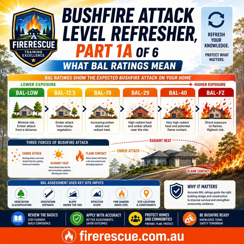
BAL Rating Guide
Quick refresher: BAL-LOW to BAL-FZ.
Part 2 of 6
Bushfire Attack on Buildings: Embers, Heat, Flame and Site Risk
Bushfire attack on buildings must be understood before site information can be judged well. This lesson explains how embers, radiant heat, flame contact, fuel, weather and nearby combustible features shape assessment thinking.
Mark each section as refreshed as you work through the article.
0% refreshed
Learning summary
Part 2 builds the fire behaviour knowledge needed for BAL assessment thinking.
Core idea
A BAL assessment learner must understand how bushfire can affect buildings before they judge site conditions.
Key risks
Embers, radiant heat and flame contact are the main bushfire attack pathways covered in this refresher.
Assessment link
Fuel, topography, weather and nearby combustible features help explain why the same building can face different exposure at different sites.
Bushfire attack on buildings starts with exposure
A building site is not assessed in isolation. The assessor must consider what may expose the building to bushfire attack.
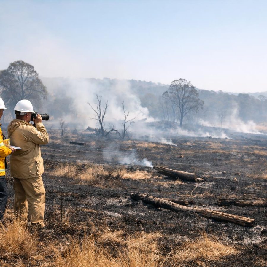
Bushfire attack on buildings can occur in several ways. A building may face burning embers, radiant heat from nearby fire, direct flame contact or a combination of these effects. Therefore, the assessor needs to understand the likely attack pathways before moving deeper into site inputs.
The PDF requires learners to analyse the cause and effect of bushfire attack on buildings. That means the learner must think beyond a simple question such as “Is there vegetation nearby?” Instead, the learner should ask how fire behaviour, site features and combustible materials may affect the building and its immediate environment.
This does not mean guessing the final BAL. At this stage, the focus is understanding exposure. Later parts of the series will cover site information, vegetation classification, distance, slope and BAL determination. However, Part 2 explains why those inputs matter in the first place.
A calm and structured approach helps. First, identify the likely attack mechanisms. Next, consider the surrounding fuel, topography and weather. Then, look at nearby features that may burn or increase exposure. Finally, record the observations so the assessment pathway remains clear.
Do not treat bushfire attack as one single hazard. Embers, radiant heat, flame contact and nearby sources of combustion can each influence assessment thinking.
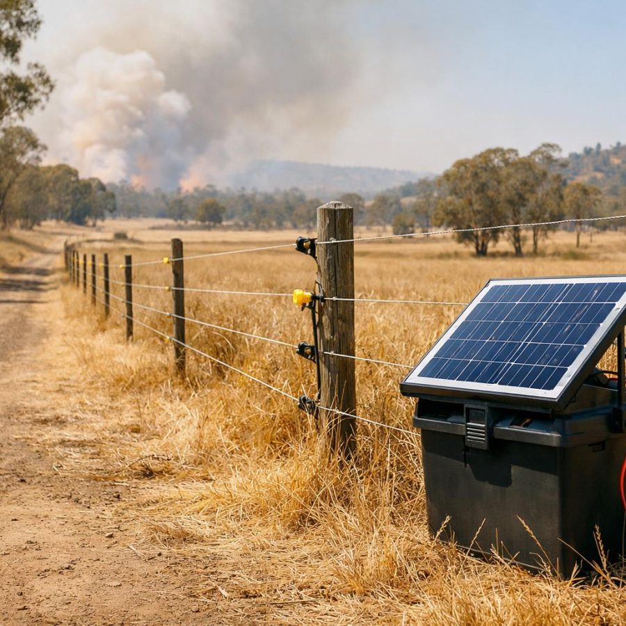
Ember attack and ember transport
Embers can move ahead of the fire front and create ignition problems around a building site.
Ember attack is one of the key bushfire attack mechanisms that learners must understand. Embers are burning or glowing pieces of material that can be lifted and carried by wind, convection and fire movement. As a result, they may reach places that are not in direct contact with the flame front.
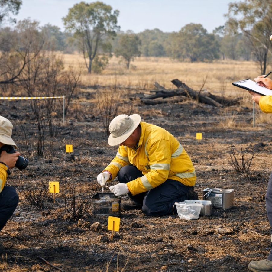
For BAL assessment learning, ember attack matters because small burning material can collect in vulnerable areas. Fine fuels, gaps, corners, roof areas, decks, stored materials, vegetation near a building and other combustible features may become important to observe. The assessor should stay within the formal method, but the site walk should still be alert and disciplined.
Ember production depends on burning fuel and fire behaviour. Transport depends on wind, terrain and fire activity. Therefore, ember risk cannot be separated from fuel, topography and weather. These factors help explain why one site may present different exposure from another.
The learner should also avoid a common mistake. Ember attack is not only a distant fire problem. Embers can also interact with the immediate environment around a building site. Therefore, the assessor must observe both broad landscape context and close site features.
Ember observation prompts
- What fuels may produce embers near or beyond the site?
- What wind or terrain factors may assist ember movement?
- Where could embers collect around the proposed building area?
- Are there vulnerable or combustible features close to the building site?
Radiant heat and what it means for assessment thinking
Radiant heat can affect buildings and people without flames touching the structure.
Radiant heat is heat energy that travels from a fire to surrounding objects. It does not require direct contact. This is why distance from vegetation, slope under vegetation, vegetation type and fire intensity become important parts of BAL assessment thinking.
A learner should understand that radiant heat can increase as fire intensity increases or as the building site is closer to the fire source. However, the final assessment must still follow the required standards and organisational procedure. The learner should not use casual judgement as a substitute for the formal method.
Radiant heat also connects to the condition and arrangement of fuel. Heavy, dry or continuous vegetation can support stronger fire behaviour than sparse or interrupted fuel. In addition, slope and wind may influence fire behaviour, which can then affect the level of exposure.
When explaining radiant heat to a site owner, plain language helps. For example, the assessor may explain that a building does not need to be touched by flames to face heat exposure. However, the assessor should avoid promising outcomes or giving advice outside their role.
Closer vegetation may increase exposure and must be measured under the required method.
Fuel amount, arrangement and moisture condition help shape fire behaviour.
Slope under vegetation can influence fire behaviour and will be covered more in Part 4.
Flame contact and the immediate environment
Flame contact is direct exposure and must be considered with the building site’s nearby features.
Flame contact occurs when flames directly reach a building, structure or nearby feature. It is an important bushfire attack mechanism because direct flame exposure can create severe conditions for materials and building elements.
For the learner, flame contact should trigger careful site thinking. What vegetation is close to the proposed building site? What structures or combustible items sit nearby? Are there flammable elements in the immediate environment? Could nearby features influence how fire reaches the building site?
The PDF refers to sources of combustion, including flammable elements and vulnerable features in and around the site. It also refers to structures and other sources adjacent to or at the proposed site. Therefore, flame contact is not only about broad vegetation. It is also about the local environment around the building site.
Good practice is to observe and record. The assessor should not ignore nearby features simply because the main vegetation hazard seems obvious. Instead, the assessor should use organisational procedures to note relevant features, constraints and limitations.
Do not remove or alter site features during an assessment unless that action is authorised and safe. Observe, measure, record and follow procedure.
Heat transfer: radiation, convection and conduction
Heat transfer helps learners understand why bushfire exposure can affect buildings in different ways.
The knowledge evidence includes heat transfer through radiation, convection and conduction. These terms help explain how heat can move from a fire to people, materials, structures and the building site environment.
Radiation is heat transfer through energy moving across space. It helps explain why a building can be affected by a fire that is nearby but not touching it. Convection is heat transfer through the movement of hot gases and air. It helps explain why wind, fire plume behaviour and terrain may matter. Conduction is heat transfer through direct contact within materials or between materials.
A BAL assessment learner does not need to become a fire scientist. However, the learner does need enough understanding to recognise why bushfire attack is more than visible flame. Heat can move, collect and affect materials in different ways.
This knowledge also supports better communication. When a site owner asks why an assessment considers vegetation, distance or slope, the assessor can explain that fire exposure involves heat movement, ember movement and potential flame contact. This keeps the explanation practical and clear.
Radiation
Heat energy moves across space from the fire to nearby surfaces or people.
Convection
Hot gases and air movement can carry heat through the fire environment.
Conduction
Heat moves through materials or between materials that are in contact.
Fuel, topography and weather as a working triangle
Bushfire behaviour changes when fuel, landform and weather interact.
The PDF requires assessors to consider the interaction between fuel, topography and weather. This is a practical working triangle for BAL assessment learning. Each part matters on its own, but the real value comes from understanding how they work together.
Fuel includes vegetation and other combustible material. Fuel amount, arrangement and moisture status can influence how fire develops and spreads. For example, dry and continuous fuel may support different fire behaviour from broken or moist fuel. However, the assessor must still use the required vegetation classification method rather than informal description alone.
Topography refers to the shape of the land. Slope is especially important because it can affect fire behaviour. A learner should also consider how landform may influence wind, access, visibility and measurement. Part 4 will focus more closely on vegetation, distance and slope.
Weather includes temperature, humidity, wind speed, wind direction, atmospheric stability and fire danger inputs. Weather can change the way fire moves, how embers travel and how intense a fire may become. Therefore, Part 3 will focus on location, fire danger and site condition inputs.
Look at what can burn, how much is present, how it is arranged and how dry it may be.
Think about slope, access, terrain limits and how the site sits in the landscape.
Consider wind, temperature, humidity and fire danger information required by procedure.
Record what was observed so later decisions can be verified and explained.
Fire development, flame height and rate of spread
These fire behaviour concepts help learners understand why bushfire exposure can escalate.
The knowledge evidence refers to fire development, growth and scale. It also includes flame height, fire intensity and rate of spread. These ideas help learners understand why bushfire attack may change across different landscapes and vegetation types.
Fire development describes how a fire starts and grows. Growth and scale describe how the fire changes as more fuel, weather and terrain factors become involved. Flame height gives a visible sign of fire behaviour, while fire intensity relates to the energy being released by the fire. Rate of spread describes how quickly the fire moves across the landscape.
For BAL assessment learning, these terms should be used to support structured thinking. They do not replace the formal BAL method. Instead, they help the learner understand why vegetation, distance, slope and fire danger inputs matter.
A disciplined assessor avoids overconfidence. Fire behaviour terms are useful, but the assessment still needs evidence, measurement and procedure. Therefore, the learner should use these concepts to improve observation, not to shortcut the process.
Spotting and junction zones
Spotting and junction zones remind learners that bushfire behaviour can be complex.
Spotting occurs when embers or burning material create new ignition points away from the main fire. This connects closely with ember production and transport. For BAL assessment learning, spotting reinforces why an assessor should not focus only on the visible fire edge or one obvious vegetation line.
Junction zones are also included in the knowledge evidence. In simple learning terms, these are areas where fire behaviour may become more complex because fire fronts, fuels, terrain or wind effects interact. The details should be handled through approved training, standards and organisational guidance.
The main lesson is clear. Bushfire behaviour can change across a site and across a landscape. Therefore, the assessor should collect information carefully and avoid assumptions. In addition, constraints and limitations should be recorded when site access or visibility affects the work.
Spotting and junction zones also support the BAL READY Cycle. The learner must understand bushfire attack, review fuel, topography and weather, then assess site inputs. This sequence keeps the work structured and reduces the risk of missing important context.
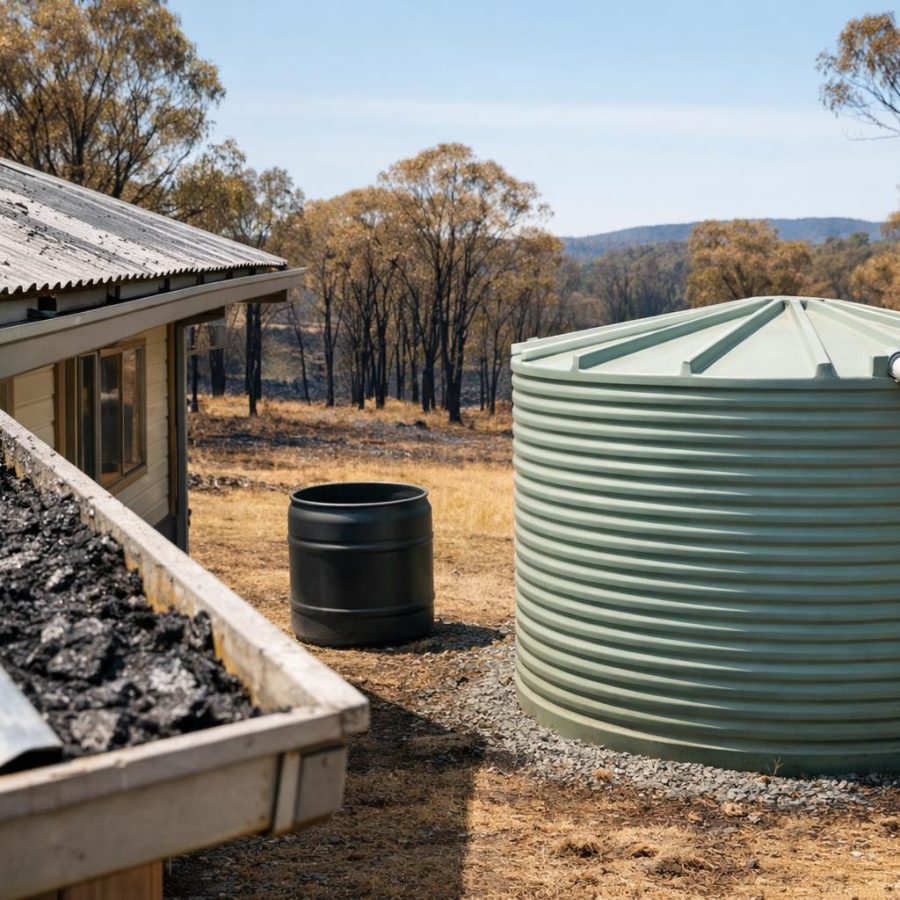
Sources of combustion around the site
Nearby combustible features can influence assessment thinking and must not be overlooked.
The PDF requires learners to identify sources of combustion and consider how they influence BAL. These sources may include flammable elements and vulnerable features in and around the site. They may also include structures and other sources adjacent to or at the proposed site.
This part of the assessment requires attention to detail. The assessor should look beyond the main vegetation area and consider the immediate environment. For example, nearby structures, combustible storage, fences, decks, landscaping elements or other site features may be relevant depending on organisational procedures and the formal assessment pathway.
The assessor should not make unsupported claims or give casual building advice. Instead, the assessor should observe, record and follow the required process. If a feature creates uncertainty, the assessor should handle it through procedure and, where required, seek guidance from the appropriate authority or supervisor.
Clear recording matters because later parts of the assessment depend on reliable information. If the assessor records what was seen, where it was located and why it may matter, the final report becomes easier to understand and verify.
Combustion source prompts
- What flammable features sit close to the proposed building site?
- Are there structures adjacent to or at the proposed site?
- Could nearby features influence ember collection, radiant heat or flame contact?
- Have relevant observations been recorded clearly under procedure?
Practical scenario drill
Use this short scenario to apply Part 2 thinking.
Scenario
You are reviewing a proposed building site near unmanaged vegetation. The owner points only to the tree line and asks whether that is the only issue. You can also see dry fine fuels near the site, a timber feature close to the proposed building area and a slope under the vegetation.
Question: What is the best assessment mindset?
Common mistakes and better habits
These habits help keep bushfire attack thinking practical and evidence-based.
Common mistake
Thinking flame contact is the only serious bushfire attack pathway.
Better habit
Consider embers, radiant heat and flame contact together, then record relevant site observations.
Common mistake
Looking only at broad vegetation and ignoring nearby combustible features.
Better habit
Check the immediate environment for flammable elements, vulnerable features and adjacent structures.
Common mistake
Using fire behaviour terms to guess a BAL before collecting proper site inputs.
Better habit
Use fire behaviour knowledge to guide observation, then follow the formal assessment pathway.
Knowledge check
Answer these quick questions before moving to Part 3.
60-second refresher drill
Use this drill as a quick recap for Part 2.
- Name the three main bushfire attack mechanisms.
- Explain how ember production and transport may affect assessment thinking.
- Describe why radiant heat does not require flame contact.
- List the three parts of the fuel, topography and weather triangle.
- Name two sources of combustion that may need to be observed around a site.
FireRescue Training Hub
Access practical fire and emergency study support resources, downloads, checklists, audio guides, and member-only course content.
- Course library
- PDF downloads
- Audio guides
- Checklists
Study support only. Not accredited training or a replacement for workplace procedures.
About the author and safety review
Ken Walker
Former Station Officer and fire service educator
Former career firefighter with extensive career and volunteer fire service experience.
Qualifications: Associate Diploma of Applied Science in Fire Technology; Institute of Fire Engineers studies.
Author profilehttps://www.firerescue.com.au/about-us/