
Dam and levee failure can become a rapidly developing flood emergency with very little warning. In the first hour, the priorities are simple but critical: confirm the threat, warn people at risk, protect life, and stop responders and the public from being trapped by fast-rising water.
Understanding the Immediate Risk
A failing dam or levee is not just a local engineering problem. It can become a downstream life-safety emergency within minutes or hours, depending on the size of the structure, the volume of stored water, the speed of failure, the terrain below, and how much warning time is available.
The consequences are also shaped by the time of day, weather, road access, and whether communities, schools, aged-care facilities, hospitals, industrial sites or critical infrastructure sit inside the likely inundation area. In some events, water levels rise slowly enough for planned evacuation. In others, the first sign may be a sudden surge downstream.
Emergency services should not wait for complete information before acting if there is credible evidence of an immediate life-threatening flood risk. The first operational objective is always life safety.
What Can Cause Dams and Levees to Fail
Dams and levees can fail for many reasons, often with more than one factor involved. Common causes include prolonged heavy rain, flood loading, overtopping, internal erosion, structural weakness, settlement, bank instability, poor maintenance, debris impact, earthquake shaking, erosion around abutments or foundations, and damage from earlier flood events.
For levees, failure may also occur because of seepage, scour, burrowing animals, vehicle damage, unauthorised excavation, or water escaping through weak points in the embankment. For dams, the risk may increase if spillways are blocked, outlets are not working as intended, or the structure is already under stress from high inflows.
Frontline responders do not need to diagnose the engineering cause before acting. What matters in the first hour is whether there is a credible sign that the structure may fail, or that downstream inundation may already be developing.
Warning Signs of Possible Dam or Levee Failure
Any sign of structural distress should be treated as urgent and escalated immediately to the responsible authority or qualified engineers. The presence of one warning sign does not prove imminent failure, but it does justify rapid assessment and protective action.
Examples of warning signs
- Unexpected water flowing through or around the structure.
- Rapid erosion on the face, toe, or downstream side.
- New cracks, settlement, bulging or other deformation.
- Slumping, movement or visible instability in the embankment.
- Water overtopping a levee or embankment.
- Increasing seepage from the structure or foundation.
- Muddy or sediment-filled seepage water.
- Sudden changes in downstream water levels.
- Reports of structural damage after storms, floods or earthquakes.
These signs can be seen by operators, emergency responders, council staff, landholders or members of the public. If they are reported, the key task is to pass the information quickly to the dam owner, levee manager, water authority, local emergency management contacts and emergency services.
The First 60 Minutes: Immediate Priorities
The first hour should be managed as a rapid, structured sequence. The exact order may change with local circumstances, but the following steps give a practical response framework.
1. Confirm the threat
Collect the best available information from the site, the responsible authority, flood intelligence, observer reports, cameras, rainfall data and upstream or downstream observations. If the structure owner or on-call engineer is available, bring them into the information flow immediately.
2. Notify and escalate
Notify emergency services, the local emergency operations structure, the dam or levee owner, water authority, council, police, and relevant state or territory emergency-management agencies. Escalation should occur as soon as there is a credible threat, even if the full extent is unclear.
3. Establish command
Set up incident control using local arrangements. Identify who is making decisions, who is collecting intelligence, who is handling warnings, and who is managing rescue and road closure tasks. Clear leadership prevents delay and duplication.
4. Identify the likely inundation area
Use available maps, flood studies, Emergency Action Plans, local knowledge and predicted inundation areas if they exist. Focus on where water is likely to go, how fast it may move, and which streets, properties and facilities are first in line.
5. Warn people at risk
Issue clear, timely and specific warnings. Tell people what is happening, where the risk is, what they should do now, and where to go. If evacuation is required, direct them away from the predicted inundation area, not simply toward the nearest road.
6. Begin evacuation where required
Prioritise people in the lowest-lying and most exposed locations first. Include people who may need more time to move, such as those in aged care, hospitals, schools, disability accommodation, tourist parks and isolated properties.
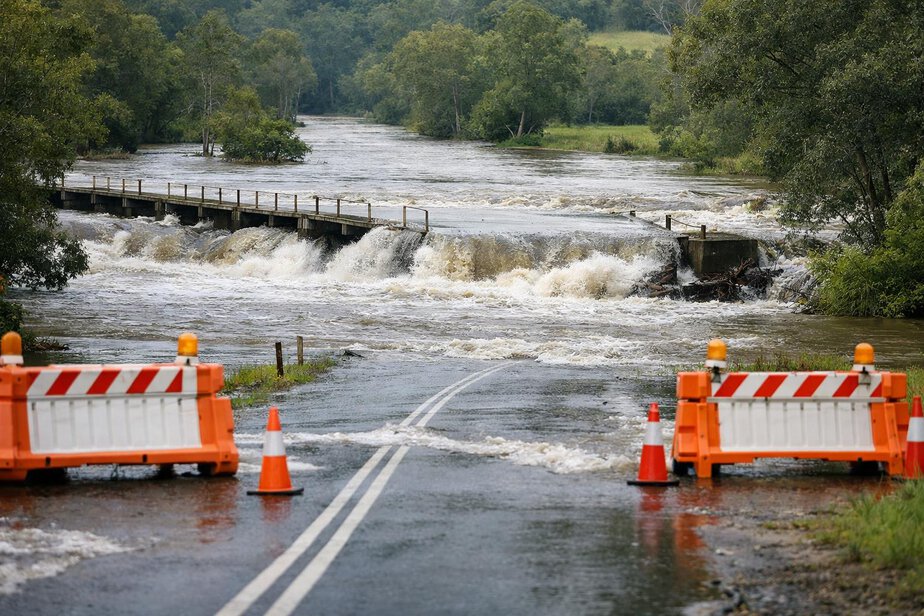
7. Close dangerous roads and crossings
Low-lying roads, bridges, causeways, culverts and river crossings may become unsafe before nearby areas are flooded. Close them early if they threaten to trap vehicles or responders.
8. Deploy rescue resources safely
Use rescue assets only where they can be deployed safely and are appropriate for flood or swift-water conditions. Avoid sending people into floodwater unless they are trained, equipped and authorised to operate there.
9. Protect critical infrastructure
Identify hospitals, aged-care facilities, schools, emergency-service facilities, water-treatment plants, electricity infrastructure and telecommunications sites that may need early protection, shutdown or evacuation planning.
10. Continually reassess conditions
Flood behaviour can change quickly. Reassess water levels, structure condition, road access, communication availability and the safety of evacuation routes throughout the first hour.
Establishing Incident Control and Coordination
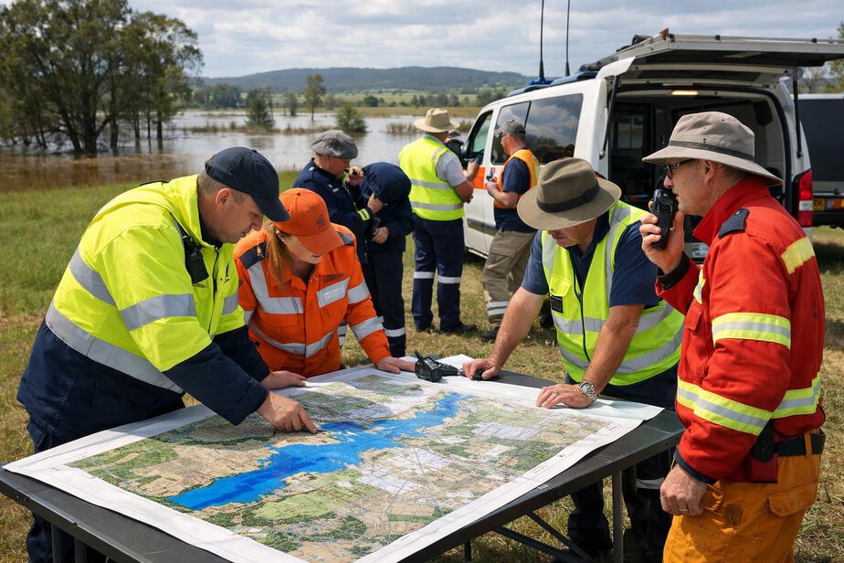
A dam or levee emergency is rarely managed by one agency alone. Incident managers should establish liaison early with the dam or levee owner, water authority, engineers, police, fire and rescue, SES, council and relevant government agencies.
This coordination helps align warnings, evacuation areas, road closures, public messages and rescue priorities. It also helps avoid conflicting instructions when communities are under pressure and time is short.
Where an Emergency Action Plan exists, it should be used. Where flood studies or inundation maps are available, they should be shared rapidly with decision-makers and field crews. If information is incomplete, responders should still act on the best available evidence rather than waiting for perfect certainty.
| Response task | Who may lead | Why it matters in the first hour |
|---|---|---|
| Structural assessment | Dam owner, levee manager, qualified engineers | Confirms whether failure is likely or underway |
| Public warnings | Police, SES, emergency management, local authorities | Moves people out of danger early |
| Road closures | Police, road authorities, councils | Prevents vehicles and responders entering flood paths |
| Rescue operations | Fire and rescue, SES, police, specialist teams | Targets life-saving tasks with safe tactics |
| Infrastructure protection | Asset owners, councils, utilities, emergency managers | Reduces cascading failures and service loss |
Warning People, Protecting Communities and Making Evacuation Decisions
Warnings should be plain language, not technical language. People need to know whether they are in the threatened area, what the likely consequence is, and what action is required now. Where local procedures exist, use them. Where the situation is fast-moving, keep messages short and direct.
Evacuation decisions should consider population density, warning time, road access, flood depth and speed, night-time conditions, and whether safe shelter is available outside the inundation area. If there is not enough time for orderly evacuation, immediate protective actions may be needed to move people to safer ground quickly.
Special attention should go to hospitals, aged-care facilities, schools, childcare centres, supported accommodation, correctional facilities and isolated communities. These locations may need early transport planning, staff support, relocation of records or medicines, and coordination with health and welfare agencies.
Public messaging should also remind people not to drive, walk or ride through floodwater. What looks shallow can conceal debris, drop-offs, strong current or damaged road surfaces.
Rescue Priorities and Swift-Water Hazards
Rescue efforts should focus on saving life first, then reducing exposure for the highest-risk people and locations. People trapped in rapidly rising water, cut off by floodwater, or in buildings that may soon be inundated should be prioritised. However, rescue teams must balance urgency with their own safety.
Swift-water hazards can be extreme. Fast-moving water can move vehicles, undermine road edges, sweep people off their feet and overturn small craft. Debris, submerged fences, trees, powerlines and damaged structures make conditions even more dangerous. Trained teams should use appropriate equipment and follow local flood rescue doctrine.
Responder safety also means resisting the pressure to enter floodwater casually. Untrained personnel should not wade, drive or launch improvised rescue attempts into moving water. If conditions are beyond local capability, request specialist flood rescue resources early.
Communicate clearly about who is operating where, what hazards are present and which areas are off limits. Accountability is essential when crews are spread across multiple access points and flood conditions are changing by the minute.
Road Closures, Infrastructure Risks and Communications Failures
Road closures should happen early enough to prevent entrapment, not after vehicles are already in trouble. Bridges, culverts and crossings may fail from scour, overtopping, debris strike or undermining. Even if the road surface still looks intact, it may no longer be safe.
Utility hazards can be widespread. Floodwater can carry electricity into buildings, create gas leaks, damage sewer lines and spread contamination. Fallen powerlines should be treated as live until the relevant authority advises otherwise. Fuel tanks, chemicals and industrial sites also need early attention because floodwater can spread contaminants beyond the original inundation zone.
Communications failures are common in large flood events. Mobile coverage, radio repeaters, power supplies and internet links may all be affected. Plan for backup communication methods, manual message passing and regular check-ins so that crews, control centres and local agencies stay connected.
Where communities become isolated, the priority is to maintain awareness of life-safety needs, access routes, welfare concerns and the stability of critical services. Isolation can change rescue requirements very quickly.
Mapping, Flood Intelligence and Prediction
Flood intelligence is most useful when it turns data into action. Use rainfall information, stream observations, dam or levee status reports, modelled inundation areas and local topography to understand where floodwaters will likely travel. If predicted inundation areas are available, they should be viewed as decision-support tools, not as exact certainty.
Maps help identify which streets are likely to flood first, which evacuation routes may be compromised, and which facilities need urgent contact. They also support decisions about where to stage resources without placing crews in the flood path.
Good mapping does not replace field observation. Downstream conditions can change because of blockages, breaches, debris, road embankments or secondary failures. Keep updating the map picture as real-world information comes in.
For Australian responders and planners, useful reference points often include the Australian Institute for Disaster Resilience, the Bureau of Meteorology, state and territory emergency-management agencies, State Emergency Services, local government arrangements, dam-safety regulators and relevant water authorities. These sources can help shape local procedures and intelligence products.
Transitioning from Immediate Response to Longer-Term Flood Operations
Once the first-hour emergency actions are underway, the incident may shift into a broader flood operation. That transition should be deliberate, not automatic. Leaders need to keep life safety front and centre while building a more stable operational structure for extended warnings, evacuations, welfare, access control and infrastructure support.
As the situation stabilises, incident managers may need to support reunification, welfare services, recovery planning, debris management, contamination assessment and ongoing public information. The key point is that the early decisions made in the first hour shape the next phase of operations.
Even then, responders should keep reassessing the possibility of further structural failure, overtopping, renewed erosion or secondary inundation. A dam or levee emergency may not end when the first water arrives; it may evolve for many hours.
Practical Key Takeaways
- Dam and levee failures can produce rapid, dangerous flooding with very little warning.
- If there is credible evidence of an immediate life-threatening risk, act before full certainty is available.
- Use the first hour to confirm the threat, escalate, establish control, warn people, evacuate where required and close dangerous routes.
- Focus on predicted inundation areas, not just the structure itself.
- Keep people away from roads, bridges and crossings that may fail or flood early.
- Do not send untrained personnel into moving water or attempt improvised rescue.
- Protect critical facilities early, especially health, care, education and utility sites.
- Coordinate closely with the dam or levee owner, engineers, police, SES, councils, water authorities and emergency-management agencies.
The best first-hour response is fast, disciplined and focused on life safety. Every local area will have its own procedures, so verify facts, maps, warning pathways and local arrangements before publication or operational use.
FireRescue Training Hub
Access practical fire and emergency study support resources, downloads, checklists, audio guides, and member-only course content.
- Course library
- PDF downloads
- Audio guides
- Checklists
Study support only. Not accredited training or a replacement for workplace procedures.
About the author and safety review
Ken Walker
Former Station Officer and fire service educator
Former career firefighter with extensive career and volunteer fire service experience.
Qualifications: Associate Diploma of Applied Science in Fire Technology; Institute of Fire Engineers studies.
Author profilehttps://www.firerescue.com.au/about-us/