Fire Safety & Emergency Response Insight
Fire-Induced Toxic Gas Mapping: A Critical Tool for Australian Fire and Rescue Services
Key takeaways: Fire-induced toxic gas mapping plays a vital role in identifying hazardous atmospheres created by combustion during fires. It supports emergency responders in making informed decisions to protect life, property, and the environment. Understanding the chemical composition and dispersion patterns of toxic gases is essential for effective risk management in Australian fire scenarios.
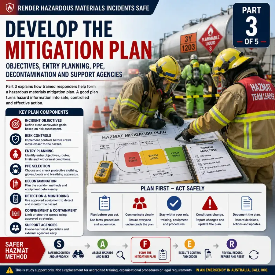
This mapping process integrates real-time monitoring, atmospheric modelling, and on-site data collection. It informs coordinated responses among Fire/Rescue, Police, Ambulance, and the State Emergency Service (SES), ensuring clear operational roles and public safety during fire incidents involving toxic gas hazards.
Background and Context
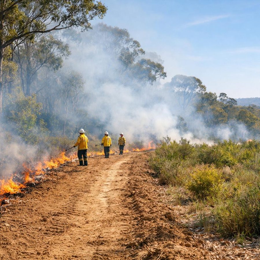
Fires, whether urban or bushfires, generate a complex mixture of gases and particulates, many of which are toxic or hazardous to human health. In Australia’s diverse environments—ranging from densely populated cities to remote rural areas—understanding the nature and spread of these gases is crucial. Toxic gases such as carbon monoxide, hydrogen cyanide, nitrogen oxides, and volatile organic compounds can severely impact firefighters, emergency personnel, and local communities if not identified and managed properly.
Fire-induced toxic gas mapping is the process of detecting, analysing, and visualising the presence and concentration of these harmful gases in and around fire scenes. This technique leverages advances in sensor technology, atmospheric dispersion models, and geographic information systems (GIS) to provide accurate and timely data. For Australian fire and emergency services, this mapping supports strategic planning, hazard mitigation, and community protection.
The significance of toxic gas mapping has grown as fire seasons in Australia have become longer and more intense, driven by climate change and urban expansion into wildland-urban interfaces. This evolving risk landscape demands sophisticated tools to anticipate hazards and reduce exposure for responders and residents alike.
Moreover, the increasing complexity of fire events, exacerbated by factors such as drought conditions and invasive species altering fuel loads, means that the types and quantities of toxic gases emitted can vary unpredictably. This variability adds layers of challenge for emergency services aiming to safeguard both their personnel and the public.
What Is Fire-Induced Toxic Gas Mapping?
Defining the Hazard Landscape
At its core, fire-induced toxic gas mapping is about understanding the invisible threat posed by gases released during combustion. Unlike visible smoke or flames, toxic gases can travel unseen and pose immediate respiratory risks, long-term health effects, or contribute to secondary hazards such as explosions. Mapping these gases involves identifying their sources, measuring concentrations, and predicting their movement influenced by weather, topography, and fire dynamics.
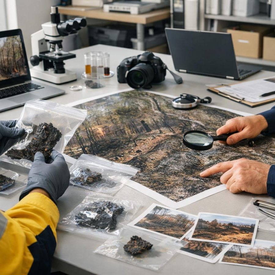
The complexity of toxic gas emissions depends on the fuel type and fire intensity. For example, burning synthetic materials in urban fires can produce highly toxic compounds like dioxins and furans, while bushfires typically emit large quantities of carbon monoxide and particulate matter. Understanding these variable emissions is essential for accurate hazard assessment.
Additionally, factors such as fire duration, temperature gradients, and smouldering phases influence the chemical composition and toxicity of emitted gases. The transformation of gases through atmospheric reactions can also create secondary pollutants that may be more harmful than the original emissions.
Techniques and Technologies
Modern approaches include deploying portable gas detectors and fixed monitoring stations on-site, using drones equipped with gas sensors for aerial surveys, and applying computer models to simulate dispersion patterns. Sensors often measure key toxicants like carbon monoxide (CO), hydrogen cyanide (HCN), sulfur dioxide (SO2), and particulate matter. Input from meteorological data such as wind speed, direction, temperature, and humidity enhances the accuracy of predictive models.
Integration of geographic information systems (GIS) allows responders to visualise concentrations overlaid on maps showing critical infrastructure, population centres, and evacuation routes. This spatial intelligence supports tactical decisions such as where to deploy crews, establish exclusion zones, or prioritise evacuations.
Emerging technologies also include satellite remote sensing and hyperspectral imaging, which can detect smoke plumes and chemical signatures over large areas. These tools complement ground-based sensors, particularly in remote or difficult-to-access regions, enhancing situational awareness during large-scale fire events.
In addition to detection, advances in sensor miniaturisation and wireless communication enable real-time data transmission to command centres. This facilitates rapid updates on toxic gas concentrations and plume movements, allowing emergency managers to adapt response strategies dynamically. Collaborative platforms that aggregate data from multiple agencies improve the comprehensiveness and accessibility of information during critical periods.
Roles and Responsibilities in Emergency Response
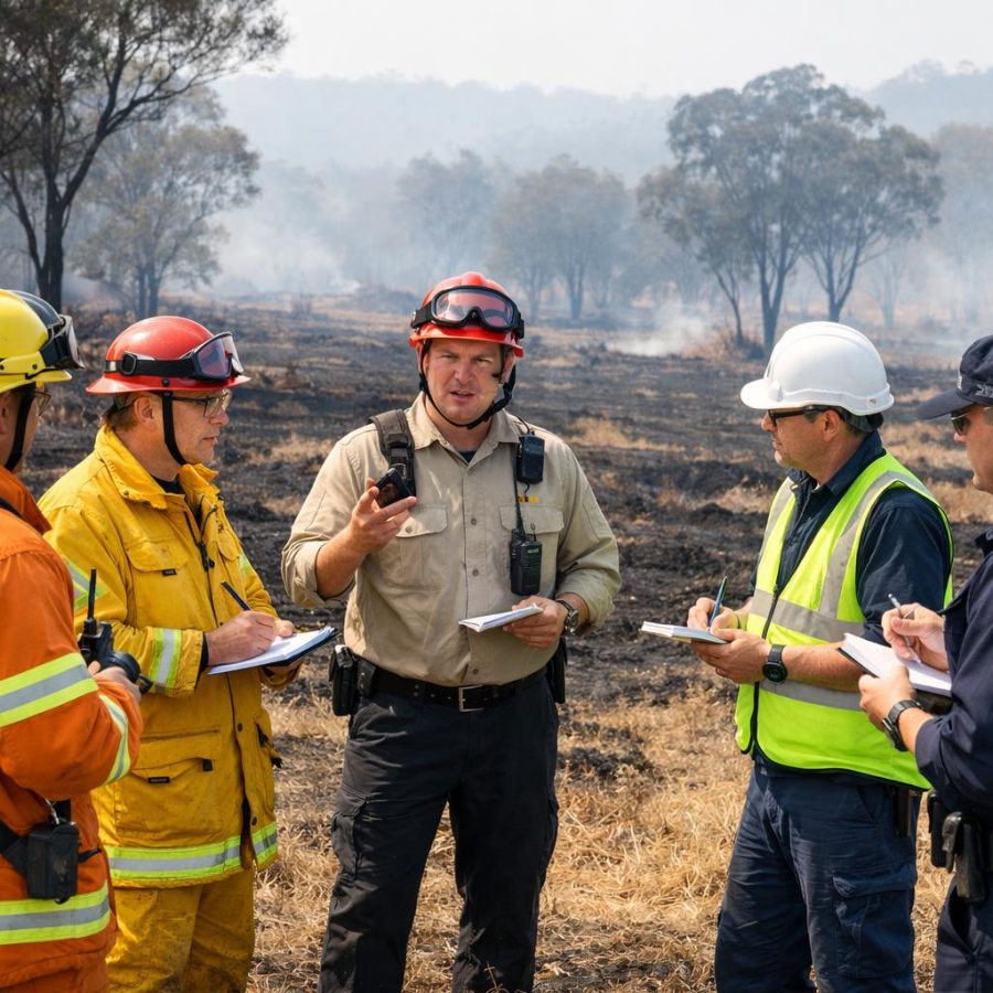
In Australia, the emergency response to fires involving toxic gases is a coordinated effort between multiple agencies, each with clear roles to ensure safety and effective incident management.
Fire and Rescue Services
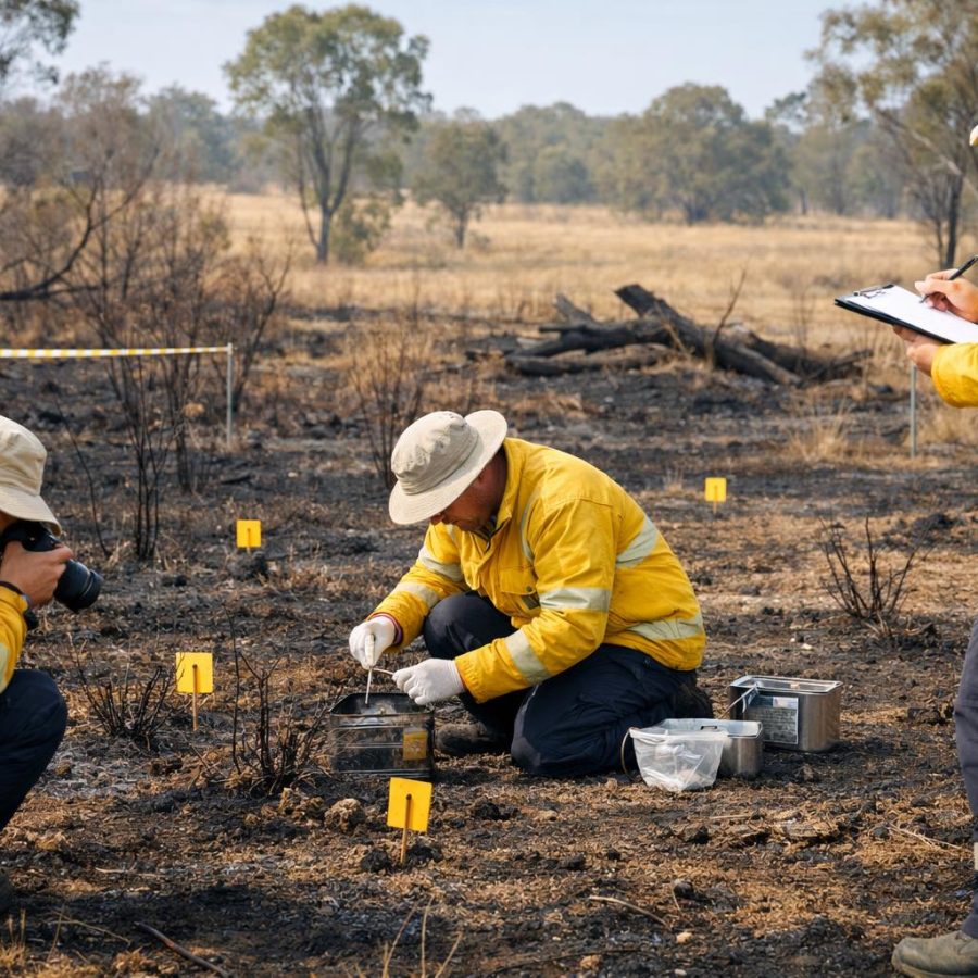
Fire and Rescue services are the primary agencies responsible for fire suppression, containment, and rescue operations. They utilise toxic gas mapping to inform safe entry points, select appropriate personal protective equipment (PPE), and determine ventilation strategies to reduce hazardous atmospheres within structures or affected zones.
Beyond immediate firefighting, Fire and Rescue teams also use toxic gas mapping data to guide post-fire assessments. This includes evaluating lingering toxic hazards that could impact re-entry for recovery operations or investigations. Understanding how toxic gases settle or dissipate over time informs decisions on when it is safe for property owners, investigators, or restoration crews to access the site.
Firefighters also benefit from training in interpreting toxic gas data, which enhances their situational awareness and personal safety during complex incidents. This knowledge helps in anticipating flashover conditions or toxic atmospheres that may not be immediately apparent.
Moreover, Fire and Rescue services often collaborate with environmental health experts to monitor post-fire air quality, ensuring that recovery efforts do not inadvertently expose workers or residents to residual toxic gases. This multi-disciplinary approach strengthens overall safety and community confidence in fire management practices.
Police
Police play a key role in maintaining public order, securing incident perimeters, and managing evacuations. Information from toxic gas mapping helps police assess which areas pose immediate risk, enabling informed decisions about cordons and traffic control to prevent public exposure.
In addition, police coordinate with other emergency services to facilitate smooth communication and ensure that evacuation orders are enforced effectively. They also assist in managing media relations and public information dissemination to avoid panic and misinformation during toxic gas incidents.
The police often serve as the primary liaison between emergency services and the community, helping to translate technical hazard information into clear public messaging that encourages compliance with safety directives.
Furthermore, police forces may deploy specialist hazardous materials (HAZMAT) units trained in toxic gas identification and containment, providing on-scene expertise that complements fire and health services. Their involvement enhances the overall coordination and safety of complex fire emergencies involving chemical hazards.
Ambulance and Health Services
Ambulance officers provide medical care to victims affected by fire or exposure to toxic gases. Early identification of gas types and concentrations assists paramedics in anticipating symptoms and preparing necessary treatments, including oxygen therapy or decontamination procedures.
Health services also rely on toxic gas mapping data for hospital preparedness. This includes anticipating patient influxes with respiratory distress or chemical exposure and ensuring that specialised equipment and staff are available. Coordination with toxicologists and hazardous materials specialists is essential for effective treatment protocols.
Hospitals may also use mapping data to implement isolation protocols to prevent secondary contamination of staff or other patients, particularly when dealing with chemical exposures from synthetic materials burning in urban fires.
Ongoing training and simulation exercises for ambulance and hospital personnel on exposure to fire-related toxic gases help improve response times and treatment outcomes. The integration of toxic gas data into emergency medical dispatch systems further enhances coordination between field responders and receiving facilities.
State Emergency Service (SES)
The SES often supports with evacuation logistics, community liaison, and assisting vulnerable populations. Toxic gas mapping data guides the SES in prioritising areas for evacuation and helps them communicate risks effectively to residents.
SES volunteers also assist in setting up temporary shelters and providing essential supplies for displaced residents. Their role in community engagement includes educating the public on recognising symptoms of toxic gas exposure and encouraging adherence to safety advisories during fire emergencies.
The SES also collaborates with local councils and health agencies to ensure that evacuation centres are equipped to handle individuals with respiratory issues or chemical sensitivities resulting from exposure to fire-related toxins.
Additionally, SES teams participate in community preparedness initiatives, such as installing early warning systems and conducting hazard awareness workshops. These efforts foster resilience and empower residents to respond effectively during toxic gas emergencies.
Practical Implications for Australian Communities
For residents and workers in areas prone to fire hazards, understanding the dangers of toxic gases can save lives. If you encounter a fire or suspect the presence of hazardous gases, the first and most important action is to call emergency services immediately by dialing 000. Provide clear information about the location and nature of the incident.
Avoid entering smoke-filled or suspiciously odorous areas, as toxic gases can cause unconsciousness or worse within seconds. Follow instructions from emergency responders and be prepared to evacuate promptly if advised. Fire-induced toxic gas mapping by responders helps minimise exposure risks and informs when it is safe to return.
Communities can also benefit from local education campaigns that explain how toxic gases are generated during fires and the importance of evacuation plans. Understanding that not all dangers from fire are visible emphasises the need for vigilance and preparedness. Schools, workplaces, and community groups should incorporate awareness of toxic gas hazards into their safety protocols, ensuring that individuals recognise early warning signs and know how to respond effectively.
Additionally, community preparedness includes maintaining updated contact information for emergency alerts and participating in local fire drills. Residents should familiarise themselves with the layout of their neighbourhood, including primary and alternative evacuation routes. Installing smoke detectors and carbon monoxide alarms in homes and workplaces adds layers of protection against unseen toxic gases.
Employers in fire-prone industries or regions are encouraged to conduct risk assessments that include the potential for toxic gas exposure during fire incidents. Workplace emergency plans should be regularly reviewed and drills conducted to ensure rapid and safe evacuation.
In rural and indigenous communities, culturally sensitive education programs can improve awareness and response to fire-induced toxic gas hazards, taking into account local knowledge and practices. Collaboration between emergency services and community leaders can enhance resilience and safety outcomes.
Furthermore, community members are encouraged to prepare emergency kits that include respiratory protection such as N95 masks or respirators, water, and first aid supplies. These items can be critical during evacuations or shelter-in-place orders when exposure to toxic gases is possible.
Challenges and Future Directions
Despite advances, mapping toxic gases during fire incidents remains challenging. Rapidly changing fire conditions, complex chemical reactions, and limitations in sensor technology can affect data accuracy. In Australia’s vast and varied landscapes, integrating remote sensing with ground-level measurements continues to evolve. The dynamic nature of fire behaviour means that toxic gas plumes can shift quickly, requiring continuous data updates and agile response strategies.
Another challenge lies in the diversity of materials burning during fires, especially in urban environments where synthetic materials release a broader spectrum of toxic compounds. This complexity demands more sophisticated sensor arrays capable of detecting a wider array of chemicals, including emerging contaminants of concern.
Research and investment in more sensitive, robust sensors, improved modelling algorithms, and real-time data sharing platforms are essential. Enhancing interoperability between emergency services and community education about toxic gas risks will further strengthen Australia’s capacity to respond safely to fire emergencies. Collaborative efforts between government agencies, academia, and industry are fostering innovation in sensor technology and data analytics, which promise to enhance the precision and speed of toxic gas mapping.
Furthermore, the integration of artificial intelligence and machine learning techniques into atmospheric modelling is beginning to offer more accurate predictions of gas dispersion under complex conditions. These technologies can help interpret vast datasets from multiple sensors and environmental inputs, enabling faster and more informed decision-making during emergencies.
Community engagement remains a cornerstone for effective toxic gas hazard management. Training programs for first responders on the latest toxic gas mapping tools and interpretation techniques improve operational safety and effectiveness. Public drills and information campaigns ensure that residents understand the risks and the rationale behind evacuation or shelter-in-place orders during fire events.
Looking ahead, integrating toxic gas mapping with broader climate and environmental monitoring systems can provide early warning of fire-prone conditions that may lead to hazardous gas releases. This proactive approach could enable pre-emptive measures such as controlled burns or temporary community alerts to reduce risk before fires ignite.
In addition, expanding cross-border collaboration and data sharing between Australian states and territories will be key to managing transboundary fire events and toxic gas hazards, especially given the increasing scale of bushfires. National frameworks that standardise toxic gas mapping protocols and response guidelines will promote consistency and efficiency in emergency management.
Ultimately, fire-induced toxic gas mapping is a vital component of modern fire and emergency management, helping to protect lives, property, and ecosystems from the invisible but deadly threats of combustion gases. As climate change increases the frequency and intensity of fires across Australia, advancing toxic gas mapping capabilities will be key to enhancing resilience and safeguarding communities across the nation.
FireRescue Training Hub
Access practical fire and emergency study support resources, downloads, checklists, audio guides, and member-only course content.
- Course library
- PDF downloads
- Audio guides
- Checklists
Study support only. Not accredited training or a replacement for workplace procedures.
About the author and safety review
Ken Walker
Former Station Officer and fire service educator
Former career firefighter with extensive career and volunteer fire service experience.
Qualifications: Associate Diploma of Applied Science in Fire Technology; Institute of Fire Engineers studies.
Author profilehttps://www.firerescue.com.au/about-us/